
Kenora topographic map
Click on the map to display elevation.
About this map
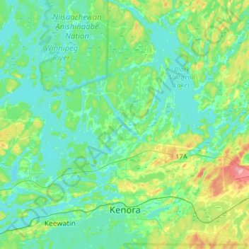
Name: Kenora topographic map, elevation, terrain.
Average elevation: 1,102 ft
Minimum elevation: 1,020 ft
Maximum elevation: 1,394 ft
Other topographic maps
Click on a map to view its topography, its elevation and its terrain.
Kakagi Lake
Canada > Ontario > Kenora District > Unorganized Kenora District
Average elevation: 1,207 ft
Slate Islands
Canada > Ontario > Kenora District > Unorganized Kenora District
Average elevation: 1,056 ft
Windermere Lake
Canada > Ontario > Kenora District > Unorganized Kenora District
Average elevation: 1,385 ft
Wolf Island
Canada > Ontario > Kenora District > Unorganized Kenora District
Average elevation: 1,073 ft
Edison Lake
Canada > Ontario > Kenora District > Unorganized Kenora District
Average elevation: 1,263 ft
Redbluff Creek;Redbluff Lake
Canada > Ontario > Kenora District > Unorganized Kenora District
Average elevation: 1,247 ft