
Catia topographic map
Click on the map to display elevation.
About this map
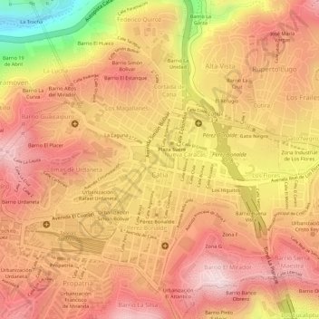
Name: Catia topographic map, elevation, terrain.
Average elevation: 3,192 ft
Minimum elevation: 2,382 ft
Maximum elevation: 3,566 ft
Other topographic maps
Click on a map to view its topography, its elevation and its terrain.
Bajada de Tazón
Venezuela > Distrito Capital > Municipio Libertador > Caracas
Average elevation: 3,314 ft
Conejo Blanco
Venezuela > Distrito Capital > Municipio Libertador > Caracas
Average elevation: 4,285 ft
Plaza Miranda
Venezuela > Distrito Capital > Municipio Libertador > Caracas
Average elevation: 3,022 ft
Jardines Quinta de Anauco
Venezuela > Distrito Capital > Municipio Libertador > Caracas
Average elevation: 3,182 ft
Plaza La Concordia
Venezuela > Distrito Capital > Municipio Libertador > Caracas
Average elevation: 3,005 ft
Plaza Caracas
Venezuela > Distrito Capital > Municipio Libertador > Caracas
Average elevation: 3,369 ft
Plaza Madariaga
Venezuela > Distrito Capital > Municipio Libertador > Caracas
Average elevation: 3,031 ft
Topo Los Mecedores
Venezuela > Distrito Capital > Municipio Libertador > Caracas
Average elevation: 5,059 ft
Plaza La Concordia
Venezuela > Distrito Capital > Municipio Libertador > Caracas
Average elevation: 3,005 ft
Cerro El Valle
Venezuela > Distrito Capital > Municipio Libertador > Caracas
Average elevation: 3,438 ft
Plaza Madariaga
Venezuela > Distrito Capital > Municipio Libertador > Caracas
Average elevation: 3,031 ft
Plaza Capuchinos
Venezuela > Distrito Capital > Municipio Libertador > Caracas
Average elevation: 3,035 ft
Castillo Blanco
Venezuela > Distrito Capital > Municipio Libertador > Caracas > Las Canoas
Average elevation: 4,085 ft