
João Monlevade topographic map
Click on the map to display elevation.
João Monlevade
The city center has an average elevation of 580.57 meters. The highest point in the municipality is in the Serra do Seara, reaching an elevation of 1,340 meters. The terrain is predominantly mountainous, with 68% of the municipal territory consisting of rolling hills and mountains, 20% undulating areas, and the remaining 12% flat terrain. The lowest elevation is found at the Jacuí Stream.
About this map
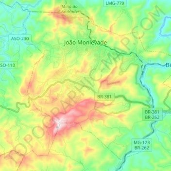
Name: João Monlevade topographic map, elevation, terrain.
Location: João Monlevade, Minas Gerais, Southeast Region, Brazil (-19.89555 -43.22336 -19.78369 -43.08942)
Average elevation: 2,667 ft
Minimum elevation: 1,765 ft
Maximum elevation: 4,370 ft
Other topographic maps
Click on a map to view its topography, its elevation and its terrain.
Serra da Mantiqueira
Brazil > Minas Gerais > Passa Quatro
The Serra da Mantiqueira is a part of the Atlantic Forest ecosystem. Despite the clearing of the land for livestock raising, the difficult access to many areas has made possible for sanctuaries of well-preserved forest to still exist, with trees such as the jacarandá, Spanish cedar, canjerana, guatambu, ipê,…
Average elevation: 7,451 ft
Bambuí
Brazil > Minas Gerais > Bambuí > Bambuí
The city center of Bambuí is located at an elevation of 706 meters on a plateau and straddles the 20th parallel. Neighboring municipalities are: Tapiraí and Córrego Danta (N), Luz (NE), Iguatama (E), Doresópolis (SE), Piumhi (S), São Roque de Minas and Medeiros (W).
Average elevation: 2,323 ft
Belo Horizonte
Brazil > Minas Gerais > Região Metropolitana de Belo Horizonte
In 1893, due to the climatic and topographic conditions, Curral Del Rey was selected by Minas Gerais governor Afonso Pena among other cities as the location for the new economic and cultural center of the state, under the new name of Cidade de Minas, or City of Minas.
Average elevation: 2,966 ft
Lagoa dos Ingleses
Brazil > Minas Gerais > Região Metropolitana de Belo Horizonte > Nova Lima
Average elevation: 4,380 ft
Pico das Agulhas Negras
Brazil > Minas Gerais > Bocaina de Minas
A mountain shelter called Abrigo Rebouças is located near the base of the peak, at an elevation of about 2,350 metres (7,710 ft). It is accessible by a gravel road (BR-485) from the BR-354 federal highway at the Garganta do Registro mountain pass, via Itatiaia National Park's north entrance. The access road…
Average elevation: 8,051 ft
São Francisco de Assis
Brazil > Minas Gerais > Região Metropolitana de Belo Horizonte > Lagoa Santa
Average elevation: 2,474 ft
Parque Municipal de Barão de Cocais
Brazil > Minas Gerais > Barão de Cocais
Average elevation: 2,559 ft
Pampulha
Brazil > Minas Gerais > Região Metropolitana de Belo Horizonte > Belo Horizonte > Pampulha
Average elevation: 2,710 ft
Itamarati
Brazil > Minas Gerais > Região Metropolitana de Belo Horizonte > Belo Horizonte
Average elevation: 2,726 ft
Contagem
Brazil > Minas Gerais > Região Metropolitana de Belo Horizonte > Contagem
The city belongs to the metropolitan mesoregion and to the microregion of Belo Horizonte, has a territorial extension of 195.2 square kilometres (75.4 square miles), and borders the municipalities of Ribeirão das Neves, Esmeraldas, Betim, Ibirité and Belo Horizonte. The elevation of the city hall is 939…
Average elevation: 2,920 ft