
Make a donation
Gear up for your next adventure:
As an Amazon Associate, this site earns from qualifying purchases at no extra cost to you.
North Rocks topographic map
Click on the map to display elevation.
Make a donation
Gear up for your next adventure:
As an Amazon Associate, this site earns from qualifying purchases at no extra cost to you.
About this map
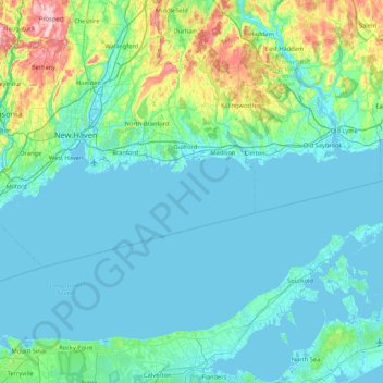
Name: North Rocks topographic map, elevation, terrain.
Average elevation: 118 ft
Minimum elevation: -10 ft
Maximum elevation: 899 ft
Make a donation
Gear up for your next adventure:
As an Amazon Associate, this site earns from qualifying purchases at no extra cost to you.
Other topographic maps
Click on a map to view its topography, its elevation and its terrain.
New Haven
United States > Connecticut > South Central Connecticut Planning Region
Average elevation: 66 ft
Madison
United States > Connecticut > South Central Connecticut Planning Region
Average elevation: 226 ft
North Branford
United States > Connecticut > South Central Connecticut Planning Region
Average elevation: 223 ft