
Surfside topographic map
Click on the map to display elevation.
About this map
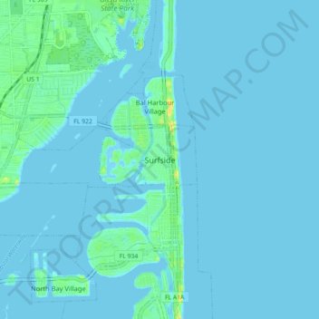
Name: Surfside topographic map, elevation, terrain.
Location: Surfside, Miami-Dade County, Florida, 33154, United States (25.83843 -80.16560 25.91843 -80.08560)
Average elevation: 10 ft
Minimum elevation: -10 ft
Maximum elevation: 82 ft
Miami-Dade County trails, hiking, mountain biking, running and outdoor activities
Other topographic maps
Click on a map to view its topography, its elevation and its terrain.
Oleta River State Park
United States > Florida > Miami-Dade County > Surfside
Average elevation: 20 ft