Geolocate

Geestland topographic map

Click on the map to display elevation.

About this map

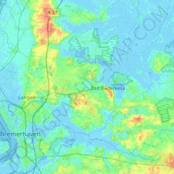
Name: Geestland topographic map, elevation, terrain.

Location: Geestland, Landkreis Cuxhaven, Lower Saxony, Germany (53.51963 8.50908 53.73726 8.99562)

Average elevation: 10 ft

Minimum elevation: -16 ft

Maximum elevation: 105 ft

Other topographic maps

Click on a map to view its topography, its elevation and its terrain.

Geestenseth

Germany > Lower Saxony > Landkreis Cuxhaven

Average elevation: 23 ft

Gear up for your next adventure:

🪄Magnetic Compass - Accurate compass for navigation
🛶Inflatable Kayak - Portable kayak for rivers, lakes, and expeditions
🧭Pro Hiking Compasses - High-accuracy liquid-filled compasses for topographic orientation
🔭Telescopic Hiking Pole - Adjustable pole for hiking stability
🔥Fast-Boil Camping Stoves - Efficient cooking systems for quick trail meals

As an Amazon Associate, this site earns from qualifying purchases at no extra cost to you.