
Make a donation
Gear up for your next adventure:
As an Amazon Associate, this site earns from qualifying purchases at no extra cost to you.
Mollens (VS) topographic map
Click on the map to display elevation.
Make a donation
Gear up for your next adventure:
As an Amazon Associate, this site earns from qualifying purchases at no extra cost to you.
Mollens (VS)
The former municipality is located in the Sierre district, on the right bank of the Rhone river. The municipality stretches from an elevation of 900 to 3,177 m (2,953 to 10,423 ft). It consists of the villages of Mollens and Cordona, the scattered settlements of Conzor, Laques and Saint-Maurice-de-Laques as well as the resort village of Aminona.
Make a donation
Gear up for your next adventure:
As an Amazon Associate, this site earns from qualifying purchases at no extra cost to you.
About this map
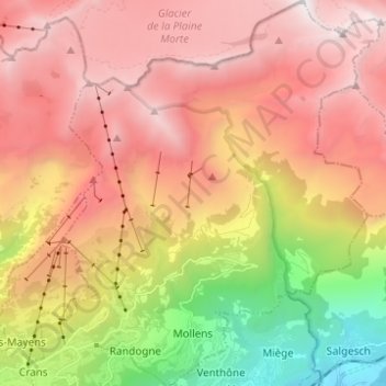
Name: Mollens (VS) topographic map, elevation, terrain.
Location: Mollens (VS), Crans-Montana, Sierre, Wallis, 3960, Switzerland (46.30380 7.49932 46.38897 7.58017)
Average elevation: 6,549 ft
Minimum elevation: 1,781 ft
Maximum elevation: 10,335 ft
Make a donation
Gear up for your next adventure:
As an Amazon Associate, this site earns from qualifying purchases at no extra cost to you.
Other topographic maps
Click on a map to view its topography, its elevation and its terrain.
Les Briesses
Switzerland > Wallis > Sierre > Crans-Montana > Chermignon-d'en-Bas
Average elevation: 3,868 ft
Make a donation
Gear up for your next adventure:
As an Amazon Associate, this site earns from qualifying purchases at no extra cost to you.