
Make a donation
Gear up for your next adventure:
As an Amazon Associate, this site earns from qualifying purchases at no extra cost to you.
Atallo topographic map
Click on the map to display elevation.
Make a donation
Gear up for your next adventure:
As an Amazon Associate, this site earns from qualifying purchases at no extra cost to you.
Atallo
La localidad de Atallo está situada en la parte norocidental del municipio de Araiz a una altitud de 224 msnm. Su término tenía limita al norte con Areso y Oreja; al este con Huici (Larráun); al sur con Arriba y al oeste con Azcárate.
Make a donation
Gear up for your next adventure:
As an Amazon Associate, this site earns from qualifying purchases at no extra cost to you.
About this map
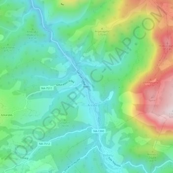
Name: Atallo topographic map, elevation, terrain.
Location: Atallo, Arriba, Araiz, Navarra, 31891, España (43.02142 -2.00672 43.06142 -1.96672)
Average elevation: 1,342 ft
Minimum elevation: 643 ft
Maximum elevation: 3,022 ft
Make a donation
Gear up for your next adventure:
As an Amazon Associate, this site earns from qualifying purchases at no extra cost to you.