Geolocate

Goodyear topographic map

Click on the map to display elevation.

About this map

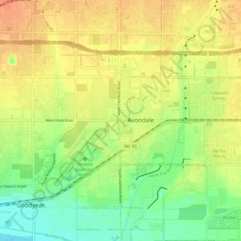
Name: Goodyear topographic map, elevation, terrain.

Location: Goodyear, Maricopa County, Arizona, 85395, United States (33.39537 -112.39760 33.47537 -112.31760)

Average elevation: 968 ft

Minimum elevation: 899 ft

Maximum elevation: 1,027 ft

Maricopa County trails, hiking, mountain biking, running and outdoor activities

Gear up for your next adventure:

🪑Portable Camp Table - Compact table for campsite meals
🧦Hiking Socks - Comfortable socks to prevent blisters on long hikes
🕶️Glacier Sunglasses - Side shields to protect eyes from high-altitude snow glare
📱Heavy-Duty Phone Cases - Drop-proof and waterproof protection for outdoor navigation
🎁Geography Themed Gifts - Unique gift ideas for map lovers and geography enthusiasts

As an Amazon Associate, this site earns from qualifying purchases at no extra cost to you.