
Make a donation
Gear up for your next adventure:
As an Amazon Associate, this site earns from qualifying purchases at no extra cost to you.
Sibiu topographic map
Click on the map to display elevation.
Make a donation
Gear up for your next adventure:
As an Amazon Associate, this site earns from qualifying purchases at no extra cost to you.
About this map
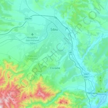
Name: Sibiu topographic map, elevation, terrain.
Location: Sibiu, Romania (45.63387 23.92191 45.85709 24.24459)
Average elevation: 1,785 ft
Minimum elevation: 1,184 ft
Maximum elevation: 4,800 ft
Make a donation
Gear up for your next adventure:
As an Amazon Associate, this site earns from qualifying purchases at no extra cost to you.
Other topographic maps
Click on a map to view its topography, its elevation and its terrain.
Make a donation
Gear up for your next adventure:
As an Amazon Associate, this site earns from qualifying purchases at no extra cost to you.
Make a donation
Gear up for your next adventure:
As an Amazon Associate, this site earns from qualifying purchases at no extra cost to you.
Make a donation
Gear up for your next adventure:
As an Amazon Associate, this site earns from qualifying purchases at no extra cost to you.
Bâlea Lake
Romania > Sibiu > Cârțișoara
Bâlea Lake (Romanian: Lacul Bâlea or Bâlea Lac, pronounced [ˈbɨle̯a]; Hungarian: Bilea-tó) is a glacier lake situated at 2,034 m of altitude in the Făgăraș Mountains, in central Romania, in Cârțișoara, Sibiu County. There are two chalets opened all the year round, a meteorological station and a…
Average elevation: 6,824 ft
Make a donation
Gear up for your next adventure:
As an Amazon Associate, this site earns from qualifying purchases at no extra cost to you.
Make a donation
Gear up for your next adventure:
As an Amazon Associate, this site earns from qualifying purchases at no extra cost to you.