
Make a donation
Gear up for your next adventure:
As an Amazon Associate, this site earns from qualifying purchases at no extra cost to you.
Folsom topographic map
Click on the map to display elevation.
Make a donation
Gear up for your next adventure:
As an Amazon Associate, this site earns from qualifying purchases at no extra cost to you.
Folsom
Folsom is situated in a wide valley near the headwaters of the Cimarron River, locally known as the Dry Cimarron, as it runs underground during part of its course through eastern New Mexico. The village is ringed by buttes, mesas, and old volcanic cones and lava flows. Most of the valley is rich grassland, with a pinyon pine and juniper forest found on slopes and in rocky areas. Ponderosa pines are found in canyons and at higher elevations. Large ranches and cattle grazing are typical of the area, although some irrigated agriculture is found downstream from Folsom. Hunting for deer, bear, elk, pronghorn, and turkey is popular on local ranches.
Make a donation
Gear up for your next adventure:
As an Amazon Associate, this site earns from qualifying purchases at no extra cost to you.
About this map
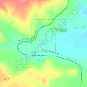
Name: Folsom topographic map, elevation, terrain.
Location: Folsom, Union County, New Mexico, United States (36.83959 -103.92685 36.85459 -103.90980)
Average elevation: 6,463 ft
Minimum elevation: 6,358 ft
Maximum elevation: 6,627 ft
Union County trails, hiking, mountain biking, running and outdoor activities
Make a donation
Gear up for your next adventure:
As an Amazon Associate, this site earns from qualifying purchases at no extra cost to you.