
Make a donation
Gear up for your next adventure:
As an Amazon Associate, this site earns from qualifying purchases at no extra cost to you.
Straßen topographic map
Click on the map to display elevation.
Make a donation
Gear up for your next adventure:
As an Amazon Associate, this site earns from qualifying purchases at no extra cost to you.
Straßen
Altenburg | Altenhofen | Asbach | Bennau | Bennauermühle | Büsch | Dasbach | Diefenau | Dinspel | Ditscheid | Drinhausen | Ehrenstein | Germscheid | Graben | Heckenhahn | Heide | Hinterplag | Hofen | Hussen | Kalscheid | Kaltehöhe | Kapaunsmühle | Köttingen | Krankel | Krumbach | Krumbachsmühle | Krumscheid | Limbach | Limberg | Löhe | Meierseifen | Niedermühlen | Oberplag | Pees | Rauenhahn | Reeg | Rindhausen | Schluten | Schöneberg | Sessenhausen | Straßen | Thelenberg | Wester | Wilsberg | Zurheiden
Make a donation
Gear up for your next adventure:
As an Amazon Associate, this site earns from qualifying purchases at no extra cost to you.
About this map
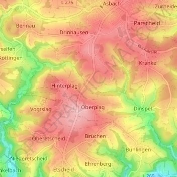
Name: Straßen topographic map, elevation, terrain.
Average elevation: 814 ft
Minimum elevation: 492 ft
Maximum elevation: 1,014 ft
Make a donation
Gear up for your next adventure:
As an Amazon Associate, this site earns from qualifying purchases at no extra cost to you.