Geolocate

Esles topographic map

Click on the map to display elevation.

About this map

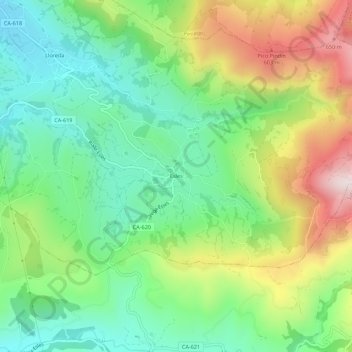
Name: Esles topographic map, elevation, terrain.

Location: Esles, Santa María de Cayón, Cantabria, 39694, Spain (43.26187 -3.82335 43.30187 -3.78335)

Average elevation: 1,106 ft

Minimum elevation: 394 ft

Maximum elevation: 2,346 ft

Gear up for your next adventure:

⛑️Personal Locator Beacon - Safety beacon for emergencies
🔦LED Headlamp - Bright and durable LED headlamp for night navigation
🔥Plasma Lighters - Windproof lighters that work in any weather condition
🎁Geography Themed Gifts - Unique gift ideas for map lovers and geography enthusiasts
🎒Day Hiking Backpack - Lightweight backpack perfect for day trips and outdoor adventures

As an Amazon Associate, this site earns from qualifying purchases at no extra cost to you.