
Beccles topographic map
Click on the map to display elevation.
About this map
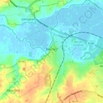
Name: Beccles topographic map, elevation, terrain.
Location: Beccles, East Suffolk, Suffolk, England, United Kingdom (52.43616 1.55204 52.47867 1.60057)
Average elevation: 39 ft
Minimum elevation: -10 ft
Maximum elevation: 118 ft
Other topographic maps
Click on a map to view its topography, its elevation and its terrain.
Site of old Orfordness Lighthouse
United Kingdom > England > Suffolk > East Suffolk > Orford
Average elevation: 0 ft
Gunton Sands
United Kingdom > England > Suffolk > East Suffolk > Lowestoft > Corton
Average elevation: 33 ft
Sutton Hoo Archeological Site
United Kingdom > England > Suffolk > East Suffolk > Sutton
Average elevation: 62 ft
Lowestoft Inner Harbour
United Kingdom > England > Suffolk > East Suffolk > Lowestoft > Oulton Broad
Average elevation: 26 ft
Rendlesham UFO Landing Site #2
United Kingdom > England > Suffolk > East Suffolk > Butley Abbey
Average elevation: 46 ft
Campsea Ashe
United Kingdom > England > Suffolk > East Suffolk > Campsea Ashe
Average elevation: 69 ft