
Thank you for supporting this site ❤️
Make a donation
Make a donation
Gear up for your next adventure:
As an Amazon Associate, this site earns from qualifying purchases at no extra cost to you.
Loveland topographic map
Click on the map to display elevation.
Thank you for supporting this site ❤️
Make a donation
Make a donation
Gear up for your next adventure:
As an Amazon Associate, this site earns from qualifying purchases at no extra cost to you.
About this map
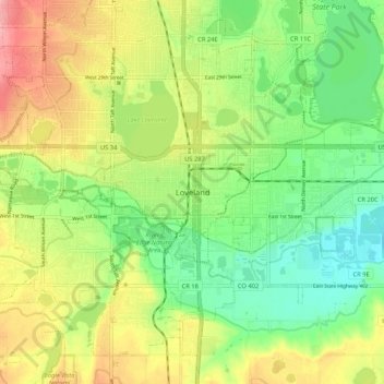
Name: Loveland topographic map, elevation, terrain.
Location: Loveland, Larimer County, Colorado, 80537, United States (40.35776 -105.11498 40.43776 -105.03498)
Average elevation: 5,003 ft
Minimum elevation: 4,859 ft
Maximum elevation: 5,194 ft
Larimer County trails, hiking, mountain biking, running and outdoor activities
Thank you for supporting this site ❤️
Make a donation
Make a donation
Gear up for your next adventure:
As an Amazon Associate, this site earns from qualifying purchases at no extra cost to you.