
Green Level topographic map
Click on the map to display elevation.
About this map
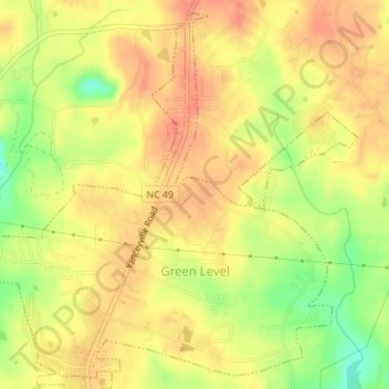
Name: Green Level topographic map, elevation, terrain.
Location: Green Level, Alamance County, North Carolina, United States (36.11324 -79.36441 36.13959 -79.32966)
Average elevation: 620 ft
Minimum elevation: 515 ft
Maximum elevation: 673 ft
Alamance County trails, hiking, mountain biking, running and outdoor activities
Other topographic maps
Click on a map to view its topography, its elevation and its terrain.
Wedgewood West
United States > North Carolina > Alamance County > Burlington
Average elevation: 666 ft
Country Club Estates
United States > North Carolina > Alamance County > Burlington
Average elevation: 640 ft