Geolocate

Peabody topographic map

Click on the map to display elevation.

About this map

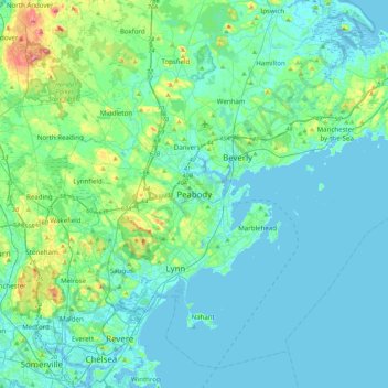
Name: Peabody topographic map, elevation, terrain.

Location: Peabody, Essex County, Massachusetts, 1970, United States (42.36787 -71.08866 42.68787 -70.76866)

Average elevation: 62 ft

Minimum elevation: -10 ft

Maximum elevation: 407 ft

Essex County trails, hiking, mountain biking, running and outdoor activities

Gear up for your next adventure:

🚪Portable Camp Chair - Foldable chair for comfort at camp
🏔️Mountain Trail Maps - High‑detail maps for popular peaks
🩳Quick‑Dry Hiking Shorts - Comfortable and quick‑dry shorts for summer hiking
🧤Tactile Hiking Gloves - Keep hands warm while operating GPS and smartphone screens
📦Gear Storage Bags - Organize and protect outdoor equipment

As an Amazon Associate, this site earns from qualifying purchases at no extra cost to you.