Geolocate

Ortisei topographic map

Click on the map to display elevation.

Ortisei

Il centro abitato si estende ad un'altitudine media di 1236 m s.l.m., dal fondovalle fin verso le pendici del Monte Rasciesa (2282 m s.l.m.), ed è situato sulla destra orografica del rio Gardena, che scorre da est a ovest e sfocia nell'Isarco presso Ponte Gardena.

About this map

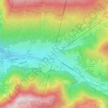
Name: Ortisei topographic map, elevation, terrain.

Location: Ortisei, Salto-Sciliar, Bolzano, Trentino-Alto Adige, 39046, Italia (46.55521 11.65214 46.59521 11.69214)

Average elevation: 5,079 ft

Minimum elevation: 3,740 ft

Maximum elevation: 6,827 ft

Gear up for your next adventure:

🔥Fast-Boil Camping Stoves - Efficient cooking systems for quick trail meals
🪶Fire Starter Kit - Reliable fire starter for survival and camping
🔥Camping Stove - Portable stove for camping and backcountry cooking
🪶Trail Camera - Capture wildlife on your hikes
🧦Hiking Socks - Comfortable socks to prevent blisters on long hikes

As an Amazon Associate, this site earns from qualifying purchases at no extra cost to you.