
Make a donation
Gear up for your next adventure:
As an Amazon Associate, this site earns from qualifying purchases at no extra cost to you.
Jatobá topographic map
Click on the map to display elevation.
Make a donation
Gear up for your next adventure:
As an Amazon Associate, this site earns from qualifying purchases at no extra cost to you.
About this map
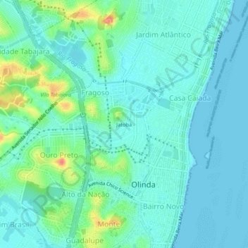
Name: Jatobá topographic map, elevation, terrain.
Average elevation: 46 ft
Minimum elevation: -10 ft
Maximum elevation: 210 ft
Make a donation
Gear up for your next adventure:
As an Amazon Associate, this site earns from qualifying purchases at no extra cost to you.
Other topographic maps
Click on a map to view its topography, its elevation and its terrain.
Alto da Conquista
Brasil > Pernambuco > Região Metropolitana do Recife > Olinda
Average elevation: 151 ft
Make a donation
Gear up for your next adventure:
As an Amazon Associate, this site earns from qualifying purchases at no extra cost to you.
Centro Histórico da Cidade de Olinda
Brasil > Pernambuco > Região Metropolitana do Recife > Olinda
Average elevation: 36 ft
Make a donation
Gear up for your next adventure:
As an Amazon Associate, this site earns from qualifying purchases at no extra cost to you.
Make a donation
Gear up for your next adventure:
As an Amazon Associate, this site earns from qualifying purchases at no extra cost to you.
Alto do Sol Nascente
Brasil > Pernambuco > Região Metropolitana do Recife > Olinda
Average elevation: 157 ft
Jardim Atlântico
Brasil > Pernambuco > Região Metropolitana do Recife > Olinda
Average elevation: 36 ft
Make a donation
Gear up for your next adventure:
As an Amazon Associate, this site earns from qualifying purchases at no extra cost to you.
Reserva de Floresta Urbana Mata do Passarinho
Brasil > Pernambuco > Região Metropolitana do Recife > Olinda > Passarinho
Average elevation: 125 ft