Geolocate

Zlatograd topographic map

Click on the map to display elevation.

About this map

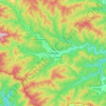
Name: Zlatograd topographic map, elevation, terrain.

Location: Zlatograd, Smolyan, 4980, Bulgaria (41.34091 25.05500 41.42091 25.13500)

Average elevation: 1,847 ft

Minimum elevation: 1,119 ft

Maximum elevation: 2,808 ft

Gear up for your next adventure:

🌲Outdoor Survival Books - Best books on survival skills
🦟Ultrasonic Repellers - Create a bug-free zone at your camp or rest stop
👟Trail Running Shoes - Lightweight shoes for trail runners
🛰️Handheld GPS Units - Professional satellite navigators for precise backcountry mapping
🔦LED Headlamp - Bright and durable LED headlamp for night navigation

As an Amazon Associate, this site earns from qualifying purchases at no extra cost to you.