
Thank you for supporting this site ❤️
Make a donation
Make a donation
Gear up for your next adventure:
As an Amazon Associate, this site earns from qualifying purchases at no extra cost to you.
Étables-sur-Mer topographic map
Click on the map to display elevation.
Thank you for supporting this site ❤️
Make a donation
Make a donation
Gear up for your next adventure:
As an Amazon Associate, this site earns from qualifying purchases at no extra cost to you.
About this map
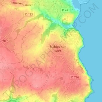
Name: Étables-sur-Mer topographic map, elevation, terrain.
Average elevation: 154 ft
Minimum elevation: 0 ft
Maximum elevation: 269 ft
Thank you for supporting this site ❤️
Make a donation
Make a donation
Gear up for your next adventure:
As an Amazon Associate, this site earns from qualifying purchases at no extra cost to you.
Other topographic maps
Click on a map to view its topography, its elevation and its terrain.
La Ville Jacob
France > Bretagne > Côtes-d'Armor > Binic-Étables-sur-Mer > Binic
Average elevation: 180 ft
Plage de la Banche
France > Bretagne > Côtes-d'Armor > Binic-Étables-sur-Mer > Binic
Average elevation: 112 ft