Geolocate

Jayuya topographic map

Click on the map to display elevation.

About this map

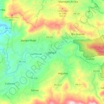
Name: Jayuya topographic map, elevation, terrain.

Location: Jayuya, Puerto Rico, 00664, United States (18.17887 -66.63237 18.25887 -66.55237)

Average elevation: 2,077 ft

Minimum elevation: 886 ft

Maximum elevation: 3,983 ft

Gear up for your next adventure:

🌡️Portable Weather Meter - Track weather conditions on the trail
📦Gear Storage Bags - Organize and protect outdoor equipment
🦺Reflective Outdoor Gear - Safety gear for low‑light conditions
🪶Trail Camera - Capture wildlife on your hikes
💧Water Filtration Bottles - Safely drink from streams and lakes while exploring

As an Amazon Associate, this site earns from qualifying purchases at no extra cost to you.