Geolocate

Rohtak topographic map

Click on the map to display elevation.

About this map

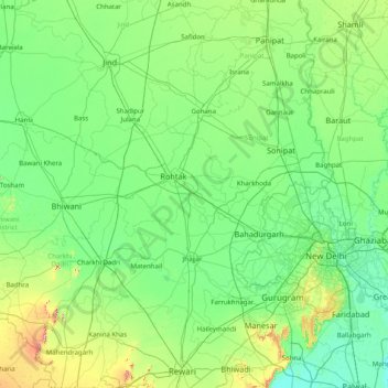
Name: Rohtak topographic map, elevation, terrain.

Location: Rohtak, Haryana, 124021, India (28.13333 75.96667 29.53333 77.36667)

Average elevation: 755 ft

Minimum elevation: 614 ft

Maximum elevation: 1,568 ft

Gear up for your next adventure:

🦺Reflective Outdoor Gear - Safety gear for low‑light conditions
🏕️Tent Footprint - Protect your tent base from wear
🎒Hydration Pack - Hands‑free water reservoir for long hikes
🪄Magnetic Compass - Accurate compass for navigation
GPS Sports Watch - GPS watch for running, hiking and training

As an Amazon Associate, this site earns from qualifying purchases at no extra cost to you.