Geolocate

Ibiza topographic map

Click on the map to display elevation.

About this map

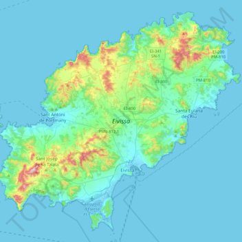
Name: Ibiza topographic map, elevation, terrain.

Location: Ibiza, Balearic Islands, Spain (38.83042 1.21327 39.11841 1.62159)

Average elevation: 171 ft

Minimum elevation: -13 ft

Maximum elevation: 1,542 ft

Other topographic maps

Click on a map to view its topography, its elevation and its terrain.

Portinatx

Spain > Balearic Islands > Ibiza

Average elevation: 138 ft

Cala Valdella

Spain > Balearic Islands > Ibiza

Average elevation: 184 ft

Gear up for your next adventure:

🏕️Family Camping Gear - Essentials for group camping trips
🧤Hiking Gloves - Protective gloves for rugged trails
🔥Fast-Boil Camping Stoves - Efficient cooking systems for quick trail meals
🌐World Map Poster - Decorative world maps with topographic info
🥩Freeze-Dried Meals - Nutritious and lightweight food for remote expeditions

As an Amazon Associate, this site earns from qualifying purchases at no extra cost to you.