
Thank you for supporting this site ❤️
Make a donation
Make a donation
Gear up for your next adventure:
As an Amazon Associate, this site earns from qualifying purchases at no extra cost to you.
Galathura topographic map
Click on the map to display elevation.
Thank you for supporting this site ❤️
Make a donation
Make a donation
Gear up for your next adventure:
As an Amazon Associate, this site earns from qualifying purchases at no extra cost to you.
About this map
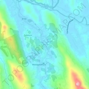
Name: Galathura topographic map, elevation, terrain.
Location: Galathura, Ratnapura District, Sabaragamuwa Province, Sri Lanka (6.68973 80.27049 6.72973 80.31049)
Average elevation: 279 ft
Minimum elevation: 30 ft
Maximum elevation: 1,378 ft
Thank you for supporting this site ❤️
Make a donation
Make a donation
Gear up for your next adventure:
As an Amazon Associate, this site earns from qualifying purchases at no extra cost to you.