Geolocate

Invermay topographic map

Click on the map to display elevation.

About this map

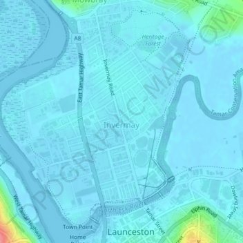
Name: Invermay topographic map, elevation, terrain.

Location: Invermay, Launceston, City of Launceston, Tasmania, 7248, Australia (-41.43467 147.11803 -41.40902 147.14616)

Average elevation: 16 ft

Minimum elevation: -20 ft

Maximum elevation: 272 ft

Other topographic maps

Click on a map to view its topography, its elevation and its terrain.

Launceston

Australia > Tasmania > Launceston

Launceston is at 41°26′31″S 147°8′42″E / 41.44194°S 147.14500°E / -41.44194; 147.14500 in the Tamar Valley, Northern Tasmania. The valley was formed by volcanic and glacial forces over 10 million years ago. The city is about 45 kilometres (28 mi) south of the Bass Strait, with its closest…

Average elevation: 715 ft

South Esk River

Australia > Tasmania > Launceston

Average elevation: 502 ft

Charlton Street Reserve

Australia > Tasmania > Launceston

Average elevation: 144 ft

Gear up for your next adventure:

🧢Sun Protection Hats - Wide-brimmed and UPF-rated hats for high-altitude sun safety
🧦Merino Wool Socks - Moisture-wicking, blister-preventing socks for long treks
🪄Magnetic Compass - Accurate compass for navigation
🧺Microfiber Travel Towels - Compact and fast-drying towels for trail use
🌄Hiking Binoculars - Compact binoculars for scenic views and trail spotting

As an Amazon Associate, this site earns from qualifying purchases at no extra cost to you.