
Thank you for supporting this site ❤️
Make a donation
Make a donation
Gear up for your next adventure:
As an Amazon Associate, this site earns from qualifying purchases at no extra cost to you.
Bassano topographic map
Click on the map to display elevation.
Thank you for supporting this site ❤️
Make a donation
Make a donation
Gear up for your next adventure:
As an Amazon Associate, this site earns from qualifying purchases at no extra cost to you.
About this map
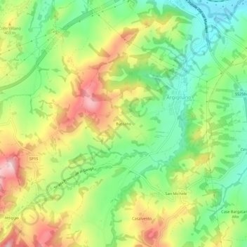
Name: Bassano topographic map, elevation, terrain.
Location: Bassano, Argignano, Fabriano, Ancona, 60044, Italy (43.30061 12.92545 43.34061 12.96545)
Average elevation: 1,161 ft
Minimum elevation: 791 ft
Maximum elevation: 1,647 ft
Thank you for supporting this site ❤️
Make a donation
Make a donation
Gear up for your next adventure:
As an Amazon Associate, this site earns from qualifying purchases at no extra cost to you.