
Ocean Isle Beach topographic map
Click on the map to display elevation.
Ocean Isle Beach
Ocean Isle Beach is a picturesque barrier island characterized by its low-lying terrain and sandy shorelines. The topography features an average elevation of about 3 feet (1 meter) above sea level, with the landscape gently sloping towards the Atlantic Ocean. The island spans approximately 7 miles in length and about half a mile in width, bordered by the Atlantic Ocean to the south and the Intracoastal Waterway to the north. This unique positioning creates a blend of beach environments and marshlands, providing ample opportunities for outdoor activities such as swimming, kayaking, and fishing. The natural beauty and coastal charm make Ocean Isle Beach a serene retreat for visitors seeking relaxation and outdoor exploration.
About this map
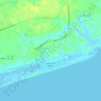
Name: Ocean Isle Beach topographic map, elevation, terrain.
Average elevation: 13 ft
Minimum elevation: -20 ft
Maximum elevation: 56 ft
Brunswick County trails, hiking, mountain biking, running and outdoor activities
Other topographic maps
Click on a map to view its topography, its elevation and its terrain.
Boiling Spring Lake Dam
United States > North Carolina > Brunswick County > Boiling Spring Lakes
Average elevation: 46 ft
Cape Fear
United States > North Carolina > Brunswick County > Bald Head Island
Average elevation: 0 ft
Bald Head Island
United States > North Carolina > Brunswick County > Bald Head Island
Average elevation: 10 ft
Cape Fear
United States > North Carolina > Brunswick County > Bald Head Island
Average elevation: 0 ft