Geolocate

Athens topographic map

Click on the map to display elevation.

About this map

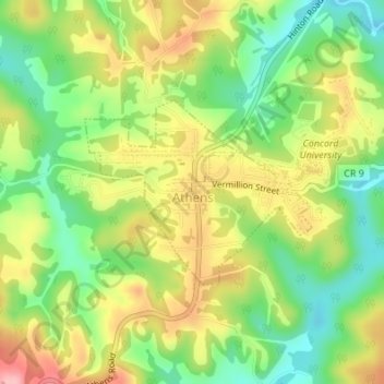
Name: Athens topographic map, elevation, terrain.

Location: Athens, Mercer County, West Virginia, United States (37.41624 -81.02576 37.42920 -81.00565)

Average elevation: 2,490 ft

Minimum elevation: 2,283 ft

Maximum elevation: 2,730 ft

Mercer County trails, hiking, mountain biking, running and outdoor activities

Other topographic maps

Click on a map to view its topography, its elevation and its terrain.

Flipping

United States > West Virginia > Mercer County > Montcalm

Average elevation: 2,467 ft

Cashers Hill

United States > West Virginia > Mercer County

Average elevation: 1,890 ft

Rock

United States > West Virginia > Mercer County

Average elevation: 2,493 ft

Flat Top

United States > West Virginia > Mercer County

Average elevation: 3,156 ft

Lake Shawnee

United States > West Virginia > Mercer County

Average elevation: 2,336 ft

Willowton

United States > West Virginia > Mercer County

Average elevation: 2,146 ft

Beeson

United States > West Virginia > Mercer County

Average elevation: 2,618 ft

Freeman

United States > West Virginia > Mercer County > Bramwell

Average elevation: 2,500 ft

Dunns

United States > West Virginia > Mercer County > Dunns

Average elevation: 2,215 ft

Gear up for your next adventure:

🎒Waterproof Dry Bags - Keep your electronics and maps dry inside your pack
🥾Women's Hiking Boots - Top-rated trail boots with ankle support and superior grip
🔥Camping Stove - Portable stove for camping and backcountry cooking
🧯Portable Fire Pit - Compact fire pit for camping spots
🛰️Satellite Messengers - Emergency SOS and two-way messaging for off-grid adventures

As an Amazon Associate, this site earns from qualifying purchases at no extra cost to you.