Geolocate

Kedarnath topographic map

Click on the map to display elevation.

About this map

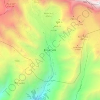
Name: Kedarnath topographic map, elevation, terrain.

Location: Kedarnath, Ukhimath, Rudraprayag, Uttarakhand, India (30.69389 79.02691 30.77389 79.10691)

Average elevation: 13,806 ft

Minimum elevation: 8,960 ft

Maximum elevation: 19,829 ft

Gear up for your next adventure:

🧭Compass with Lanyard - Easy‑carry compass for navigation
🌐World Map Poster - Decorative world maps with topographic info
🎒Day Hiking Backpack - Lightweight backpack perfect for day trips and outdoor adventures
🔥Fast-Boil Camping Stoves - Efficient cooking systems for quick trail meals
🧢Outdoor Hiking Hat - Sun protection hat for outdoor explorers

As an Amazon Associate, this site earns from qualifying purchases at no extra cost to you.