Geolocate

Progreso topographic map

Click on the map to display elevation.

About this map

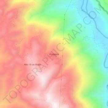
Name: Progreso topographic map, elevation, terrain.

Location: Progreso, Caranavi, La Paz, Bolivia (-15.92068 -67.60212 -15.88068 -67.56212)

Average elevation: 3,720 ft

Minimum elevation: 2,018 ft

Maximum elevation: 5,115 ft

Other topographic maps

Click on a map to view its topography, its elevation and its terrain.

Nueva Llusta Segunda

Bolivia > La Paz > Caranavi > Caranavi

Average elevation: 5,938 ft

Taipiplaya

Bolivia > La Paz > Caranavi > Caranavi

Average elevation: 3,015 ft

Gear up for your next adventure:

🌎3D Topographic Globes - Raised relief globes for a tactile understanding of geography
🛡️Insect Repellent - Protection against bugs during outdoor activities
🥩Freeze-Dried Meals - Nutritious and lightweight food for remote expeditions
🔊Portable Camp Speaker - Music and alerts at camp
🔌Solar Panel Charger - Charge gear sustainably outdoors

As an Amazon Associate, this site earns from qualifying purchases at no extra cost to you.