
Village of Sleepy Hollow topographic map
Interactive map
Click on the map to display elevation.
About this map
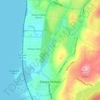
Name: Village of Sleepy Hollow topographic map, elevation, terrain.
Average elevation: 151 ft
Minimum elevation: 0 ft
Maximum elevation: 482 ft
Other topographic maps
Click on a map to view its topography, its elevation and its terrain.
Thornwood
United States > New York > Westchester County > Town of Mount Pleasant
Thornwood, Town of Mount Pleasant, Westchester County, New York, 10594, United States
Average elevation: 397 ft
Hawthorne
United States > New York > Westchester County > Town of Mount Pleasant
Hawthorne, Town of Mount Pleasant, Westchester County, New York, 10532, United States
Average elevation: 374 ft
Valhalla
United States > New York > Westchester County > Town of Mount Pleasant
Valhalla, Town of Mount Pleasant, Westchester County, New York, 10595, United States
Average elevation: 358 ft
Village of Pleasantville
United States > New York > Westchester County > Town of Mount Pleasant
Village of Pleasantville, Town of Mount Pleasant, Westchester County, New York, 10570, United States
Average elevation: 407 ft