
Make a donation
Gear up for your next adventure:
As an Amazon Associate, this site earns from qualifying purchases at no extra cost to you.
Table Rock Mountain topographic map
Click on the map to display elevation.
Make a donation
Gear up for your next adventure:
As an Amazon Associate, this site earns from qualifying purchases at no extra cost to you.
About this map
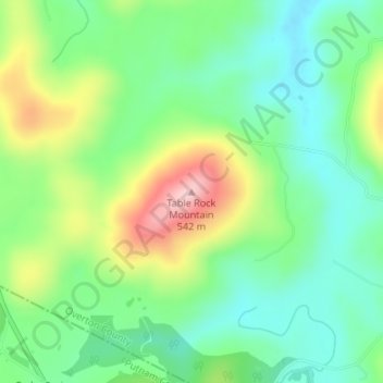
Name: Table Rock Mountain topographic map, elevation, terrain.
Average elevation: 1,375 ft
Minimum elevation: 1,145 ft
Maximum elevation: 1,811 ft
Make a donation
Gear up for your next adventure:
As an Amazon Associate, this site earns from qualifying purchases at no extra cost to you.
Other topographic maps
Click on a map to view its topography, its elevation and its terrain.
Livingston
United States > Tennessee > Overton County
According to the United States Census Bureau, the town has a total area of 5.2 square miles (13 km2), of which 5.1 square miles (13 km2) is land and 0.04 square miles (0.10 km2) (0.77%) is water. Elevation in the town ranges from 1,027 ft (313 m) to 1700 ft (518.16 m)
Average elevation: 1,145 ft