Geolocate
👉 Easily get elevation data in JSON, GeoTIFF and KML formats using Elevation API
Thank you for supporting this site ❤️
Make a donation

Edington topographic map

Click on the map to display elevation.

About this map

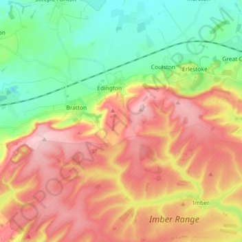
Name: Edington topographic map, elevation, terrain.

Location: Edington, Wiltshire, England, United Kingdom (51.22135 -2.13993 51.31037 -2.07598)

Average elevation: 436 ft

Minimum elevation: 141 ft

Maximum elevation: 768 ft

Other topographic maps

Click on a map to view its topography, its elevation and its terrain.

Eysey

United Kingdom > England > Wiltshire > Cricklade

Average elevation: 266 ft

Reybridge

United Kingdom > England > Wiltshire > Lacock

Average elevation: 213 ft

Nomansland

United Kingdom > England > Wiltshire

Average elevation: 223 ft

Hawkeridge

United Kingdom > England > Wiltshire > Hawkeridge

Average elevation: 187 ft

Botley Hill

United Kingdom > England > Wiltshire

Average elevation: 584 ft

Jugg's Wood

United Kingdom > England > Wiltshire > Froxfield

Average elevation: 430 ft

Deptford

United Kingdom > England > Wiltshire > Wylye > Deptford

Average elevation: 361 ft

Gear up for your next adventure:

🥾Women's Hiking Boots - Top-rated trail boots with ankle support and superior grip
🌡️Portable Weather Meter - Track weather conditions on the trail
🧯Emergency Survival Kit - All‑in‑one survival essentials for the backcountry
🛏️Cold Weather Sleeping Bag - Warm sleeping bag for cold conditions
🥄Camping Utensil Set - Lightweight utensils for outdoor meals

As an Amazon Associate, this site earns from qualifying purchases at no extra cost to you.