Geolocate

Seocho-gu topographic map

Click on the map to display elevation.

About this map

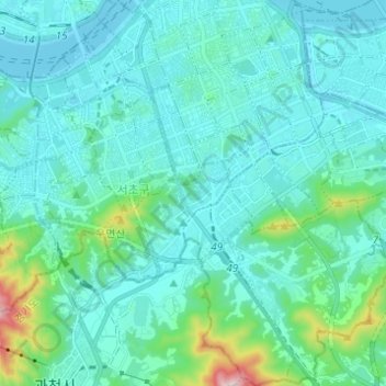
Name: Seocho-gu topographic map, elevation, terrain.

Location: Seocho-gu, Seoul, South Korea (37.42854 126.98055 37.52588 127.09645)

Average elevation: 246 ft

Minimum elevation: 10 ft

Maximum elevation: 1,785 ft

Other topographic maps

Click on a map to view its topography, its elevation and its terrain.

Susong-dong

South Korea > Seoul > Susong-dong

Average elevation: 223 ft

Gye-dong

South Korea > Seoul

Average elevation: 249 ft

Inwangsan (Mt.)

South Korea > Seoul

Average elevation: 371 ft

Gear up for your next adventure:

🦶Hiking Gaiters - Keep debris and water out of your boots
🥤Water Filter Bottle - All‑in‑one filter bottle for safe hydration
📌Outdoor GPS Map App - Apps and devices for digital topographic navigation
🔪Outdoor Multitools - Essential survival tools for gear repair and field use
🗺️NatGeo Topo Maps - High-quality waterproof printed topographic maps of US Parks

As an Amazon Associate, this site earns from qualifying purchases at no extra cost to you.