Geolocate

Morni topographic map

Click on the map to display elevation.

About this map

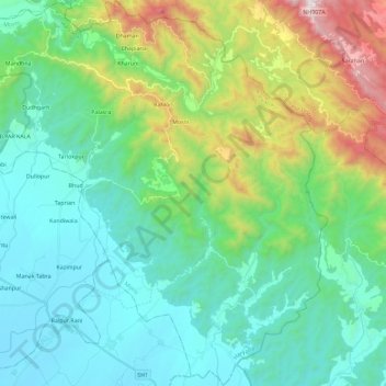
Name: Morni topographic map, elevation, terrain.

Location: Morni, Panchkula District, Haryana, 134205, India (30.55215 76.95075 30.74919 77.17584)

Average elevation: 2,208 ft

Minimum elevation: 1,047 ft

Maximum elevation: 5,892 ft

Other topographic maps

Click on a map to view its topography, its elevation and its terrain.

Khedar

India > Haryana > Barwala

Average elevation: 715 ft

Rohtak

India > Haryana > Rohtak

Average elevation: 728 ft

Murthal

India > Haryana > Sonipat

Average elevation: 719 ft

Malra

India > Haryana > Mahendragarh > Malra

Average elevation: 837 ft

Faridabad

India > Haryana > Faridabad

Average elevation: 712 ft

Bhud Pur

India > Haryana > Rewari > Bhud Pur

Average elevation: 797 ft

Central Park

India > Haryana > Gurugram

Average elevation: 814 ft

Panipat

India > Haryana > Panipat

Panipat is located at 29°23′15″N 76°58′12″E / 29.3875°N 76.9700°E / 29.3875; 76.9700.[12] It has an average elevation of 219 metres (718 feet).

Average elevation: 771 ft

Kundli

India > Haryana > Sonipat

Average elevation: 699 ft

Gear up for your next adventure:

🎒Gear Packing Cubes - Organize your backpack efficiently
😴Insulated Sleeping Pads - Compact and warm pads for high-elevation camping
🧭Orienteering Set - Complete compass and map reading kit
🎒Waterproof Dry Bags - Keep your electronics and maps dry inside your pack
🔭Stargazing Telescopes - Perfect for camping in low-light pollution areas shown on maps

As an Amazon Associate, this site earns from qualifying purchases at no extra cost to you.