Geolocate

Fredericktown topographic map

Click on the map to display elevation.

About this map

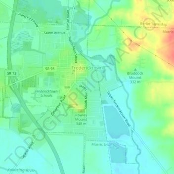
Name: Fredericktown topographic map, elevation, terrain.

Location: Fredericktown, Knox County, Ohio, United States (40.46389 -82.56934 40.49147 -82.52814)

Average elevation: 1,086 ft

Minimum elevation: 1,033 ft

Maximum elevation: 1,207 ft

Knox County trails, hiking, mountain biking, running and outdoor activities

Other topographic maps

Click on a map to view its topography, its elevation and its terrain.

Zuck

United States > Ohio > Knox County

Average elevation: 968 ft

Howard

United States > Ohio > Knox County

Average elevation: 978 ft

Howard

United States > Ohio > Knox County

Average elevation: 978 ft

Gear up for your next adventure:

🥇GPS Hiking Watch - Multi‑sport GPS watch with navigation and trail tracking
🧦Merino Wool Socks - Moisture-wicking, blister-preventing socks for long treks
🧯Portable Fire Pit - Compact fire pit for camping spots
🧭Hiking Compass - Precision compass for reliable navigation in the wilderness
🔪Outdoor Multitools - Essential survival tools for gear repair and field use

As an Amazon Associate, this site earns from qualifying purchases at no extra cost to you.