
Make a donation
Gear up for your next adventure:
As an Amazon Associate, this site earns from qualifying purchases at no extra cost to you.
Calascio topographic map
Click on the map to display elevation.
Make a donation
Gear up for your next adventure:
As an Amazon Associate, this site earns from qualifying purchases at no extra cost to you.
Calascio
Il borgo è situato nell'entroterra abruzzese, nel parte meridionale del massiccio del Gran Sasso d'Italia, al di sotto della vasta piana di Campo Imperatore, in posizione panoramica sulla valle del Tirino, ad un'altitudine di poco superiore ai 1200 m s.l.m.; al di sopra del paese vi è la frazione di Rocca Calascio, ora riscoperta e ristrutturata, con il suo castello, arroccato in cima ad un monte, a 1460 m.
Make a donation
Gear up for your next adventure:
As an Amazon Associate, this site earns from qualifying purchases at no extra cost to you.
About this map
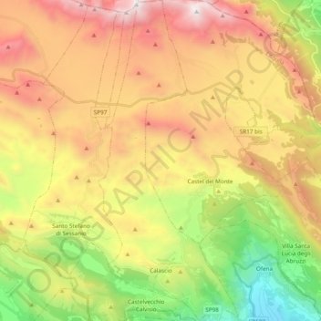
Name: Calascio topographic map, elevation, terrain.
Location: Calascio, L'Aquila, Abruzzo, Italia (42.30364 13.66001 42.44413 13.74321)
Average elevation: 4,596 ft
Minimum elevation: 1,178 ft
Maximum elevation: 8,346 ft
Make a donation
Gear up for your next adventure:
As an Amazon Associate, this site earns from qualifying purchases at no extra cost to you.
Other topographic maps
Click on a map to view its topography, its elevation and its terrain.