
Make a donation
Gear up for your next adventure:
As an Amazon Associate, this site earns from qualifying purchases at no extra cost to you.
Ust-Nera topographic map
Click on the map to display elevation.
Make a donation
Gear up for your next adventure:
As an Amazon Associate, this site earns from qualifying purchases at no extra cost to you.
About this map
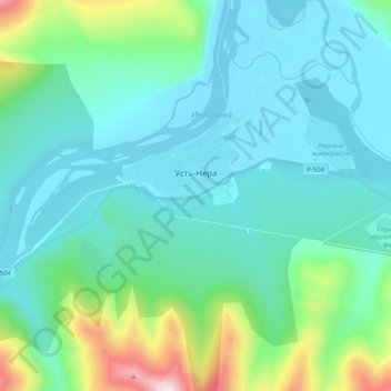
Name: Ust-Nera topographic map, elevation, terrain.
Average elevation: 2,119 ft
Minimum elevation: 1,562 ft
Maximum elevation: 4,836 ft
Make a donation
Gear up for your next adventure:
As an Amazon Associate, this site earns from qualifying purchases at no extra cost to you.
Other topographic maps
Click on a map to view its topography, its elevation and its terrain.
Oymyakon
Russia > Sakha Republic > Oymyakonsky Ulus
With an extreme subarctic climate (Köppen climate classification Dfd), Oymyakon is known as one of the places considered the Northern Pole of Cold, the other being the town of Verkhoyansk, located 629 km (391 mi) away by air. The weather station is in a valley between Oymyakon and Tomtor. The station is at…
Average elevation: 2,228 ft
Oymyakon
Russia > Sakha Republic > Oymyakonsky Ulus
With an extreme subarctic climate (Köppen climate classification Dfd, Trewartha climate classification Ecle), Oymyakon is known as one of the places considered the Northern Pole of Cold, the other being the town of Verkhoyansk, located 629 km (391 mi) away by air. The weather station is in a valley between…
Average elevation: 2,228 ft
Oymyakon
Russia > Sakha Republic > Oymyakonsky Ulus
With an extreme subarctic climate (Köppen climate classification Dfd), Oymyakon is known as one of the places considered the Northern Pole of Cold, the other being the town of Verkhoyansk, located 629 km (391 mi) away by air. The weather station is in a valley between Oymyakon and Tomtor. The station is at…
Average elevation: 2,228 ft
Make a donation
Gear up for your next adventure:
As an Amazon Associate, this site earns from qualifying purchases at no extra cost to you.
Oymyakon
Russia > Sakha Republic > Oymyakonsky Ulus
With an extreme subarctic climate (Köppen climate classification Dfd, Trewartha climate classification Ecle), Oymyakon is known as one of the places considered the Northern Pole of Cold, the other being the town of Verkhoyansk, located 629 km (391 mi) away by air. The weather station is in a valley between…
Average elevation: 2,228 ft
Make a donation
Gear up for your next adventure:
As an Amazon Associate, this site earns from qualifying purchases at no extra cost to you.