Geolocate

Springfield topographic map

Click on the map to display elevation.

About this map

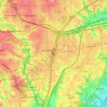
Name: Springfield topographic map, elevation, terrain.

Location: Springfield, Fairfax County, Virginia, 22150, United States (38.73804 -77.21878 38.81206 -77.15308)

Average elevation: 223 ft

Minimum elevation: 20 ft

Maximum elevation: 338 ft

Fairfax County trails, hiking, mountain biking, running and outdoor activities

Gear up for your next adventure:

🧭Outdoor Navigation Book - Learn advanced navigation skills
🪑Portable Camp Table - Compact table for campsite meals
📶Vehicle Signal Boosters - Improve reception in rural areas while driving to trailheads
Solar GPS Watches - Advanced multisport watches with built-in topographic maps
👟Men's Trail Runners - Lightweight footwear for fast-paced exploration and light hiking

As an Amazon Associate, this site earns from qualifying purchases at no extra cost to you.