
Thank you for supporting this site ❤️
Make a donation
Make a donation
Gear up for your next adventure:
As an Amazon Associate, this site earns from qualifying purchases at no extra cost to you.
Pampigny topographic map
Click on the map to display elevation.
Thank you for supporting this site ❤️
Make a donation
Make a donation
Gear up for your next adventure:
As an Amazon Associate, this site earns from qualifying purchases at no extra cost to you.
About this map
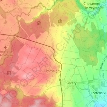
Name: Pampigny topographic map, elevation, terrain.
Location: Pampigny, Hautemorges, District de Morges, Vaud, 1142, Suisse (46.56639 6.38696 46.60863 6.44611)
Average elevation: 2,123 ft
Minimum elevation: 1,827 ft
Maximum elevation: 2,316 ft
Thank you for supporting this site ❤️
Make a donation
Make a donation
Gear up for your next adventure:
As an Amazon Associate, this site earns from qualifying purchases at no extra cost to you.