
Make a donation
Gear up for your next adventure:
As an Amazon Associate, this site earns from qualifying purchases at no extra cost to you.
Volos Municipality topographic map
Click on the map to display elevation.
Make a donation
Gear up for your next adventure:
As an Amazon Associate, this site earns from qualifying purchases at no extra cost to you.
About this map
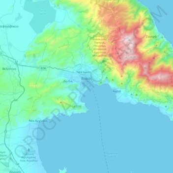
Name: Volos Municipality topographic map, elevation, terrain.
Average elevation: 748 ft
Minimum elevation: -10 ft
Maximum elevation: 5,262 ft
Make a donation
Gear up for your next adventure:
As an Amazon Associate, this site earns from qualifying purchases at no extra cost to you.
Other topographic maps
Click on a map to view its topography, its elevation and its terrain.
Mouresi
Greece > Thessaly > Regional Unit of Magnesia > Municipal Unit of Mouresi
Average elevation: 994 ft
Συκή
Greece > Thessaly > Regional Unit of Magnesia > Municipal Unit of Afetes
Average elevation: 722 ft
Makrinitsa
Greece > Thessaly > Regional Unit of Magnesia > Volos Municipality
Average elevation: 2,175 ft
Makrinitsa
Greece > Thessaly > Regional Unit of Magnesia > Volos Municipality
Average elevation: 2,175 ft
Make a donation
Gear up for your next adventure:
As an Amazon Associate, this site earns from qualifying purchases at no extra cost to you.
Ζαγορά
Greece > Thessaly > Regional Unit of Magnesia > Municipal Unit of Zagora
Average elevation: 1,680 ft
Makrinitsa
Greece > Thessaly > Regional Unit of Magnesia > Volos Municipality
Average elevation: 2,175 ft
Ριζόμυλος
Greece > Thessaly > Regional Unit of Magnesia > Municipal Unit of Karla
Average elevation: 200 ft