Geolocate

Ten Mile topographic map

Click on the map to display elevation.

About this map

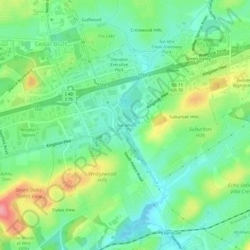
Name: Ten Mile topographic map, elevation, terrain.

Location: Ten Mile, Knoxville, Knox County, East Tennessee, Tennessee, 37923, United States (35.89341 -84.09963 35.93341 -84.05963)

Average elevation: 955 ft

Minimum elevation: 843 ft

Maximum elevation: 1,168 ft

Knox County trails, hiking, mountain biking, running and outdoor activities

Other topographic maps

Click on a map to view its topography, its elevation and its terrain.

Dead Horse Lake

United States > Tennessee > Knox County > Knoxville

Average elevation: 971 ft

Gear up for your next adventure:

🪶Survival Guide Book - Expert advice for emergency preparedness
📶Satellite Messenger - Communication device off‑grid
🗺️NatGeo Topo Maps - High-quality waterproof printed topographic maps of US Parks
🎒Trail Energy Bars - High‑calorie bars for hiking energy
🥇GPS Hiking Watch - Multi‑sport GPS watch with navigation and trail tracking

As an Amazon Associate, this site earns from qualifying purchases at no extra cost to you.