
Bridgetown topographic map
Click on the map to display elevation.
About this map
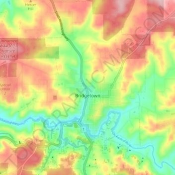
Name: Bridgetown topographic map, elevation, terrain.
Location: Bridgetown, Western Australia, 6255, Australia (-33.99004 116.09141 -33.91999 116.16559)
Average elevation: 732 ft
Minimum elevation: 417 ft
Maximum elevation: 1,063 ft
Other topographic maps
Click on a map to view its topography, its elevation and its terrain.
Perth
Perth, the capital of Western Australia, is situated on the Swan Coastal Plain, a flat expanse of sandy soil nestled between the Indian Ocean to the west and the Darling Scarp to the east. The Darling Scarp, also known as the Darling Range, is a low escarpment that extends north–south, marking a distinct…
Average elevation: 85 ft
Bluff Knoll
Due to its elevation, Bluff Knoll and the surrounding peaks of the Stirling Ranges are some of only a few places to experience regular snowfalls in Western Australia. When snow is forecast by the Bureau of Meteorology it attracts hikers from all over the southwest region to experience it.
Average elevation: 2,175 ft
Mount Meharry
The summit of Mount Meharry can be reached from the Great Northern Highway via an unsealed road 16 kilometres (9.9 mi) in length and a vehicular track 21 kilometres (13 mi) in length. Permission should be sought from the managers of the land over which the road and track pass. These are Juna Downs Station and…
Average elevation: 3,379 ft