
Thank you for supporting this site ❤️
Make a donation
Make a donation
Gear up for your next adventure:
As an Amazon Associate, this site earns from qualifying purchases at no extra cost to you.
Lago topographic map
Click on the map to display elevation.
Thank you for supporting this site ❤️
Make a donation
Make a donation
Gear up for your next adventure:
As an Amazon Associate, this site earns from qualifying purchases at no extra cost to you.
About this map
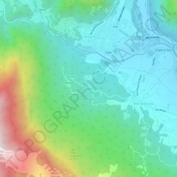
Name: Lago topographic map, elevation, terrain.
Location: Lago, Velo d'Astico, Vicenza, Veneto, 36011, Italia (45.77177 11.32999 45.81177 11.36999)
Average elevation: 1,962 ft
Minimum elevation: 833 ft
Maximum elevation: 5,177 ft
Thank you for supporting this site ❤️
Make a donation
Make a donation
Gear up for your next adventure:
As an Amazon Associate, this site earns from qualifying purchases at no extra cost to you.