
Make a donation
Gear up for your next adventure:
As an Amazon Associate, this site earns from qualifying purchases at no extra cost to you.
Chaineux topographic map
Click on the map to display elevation.
Make a donation
Gear up for your next adventure:
As an Amazon Associate, this site earns from qualifying purchases at no extra cost to you.
Chaineux
Chaineux ligt op het Plateau van Herve, op een hoogte van ongeveer 260 meter. De omgeving is landelijk, maar het in de onmiddellijke nabijheid gelegen Knooppunt Battice heeft het oorspronkelijke landschap sterk doorsneden.
Make a donation
Gear up for your next adventure:
As an Amazon Associate, this site earns from qualifying purchases at no extra cost to you.
About this map
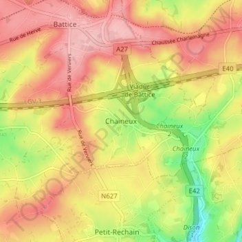
Name: Chaineux topographic map, elevation, terrain.
Location: Chaineux, Verviers, Luik, Wallonië, 4651, België (50.61194 5.81427 50.65194 5.85427)
Average elevation: 915 ft
Minimum elevation: 646 ft
Maximum elevation: 1,099 ft
Make a donation
Gear up for your next adventure:
As an Amazon Associate, this site earns from qualifying purchases at no extra cost to you.