
Thank you for supporting this site ❤️
Make a donation
Make a donation
Gear up for your next adventure:
As an Amazon Associate, this site earns from qualifying purchases at no extra cost to you.
Godigamuwa topographic map
Click on the map to display elevation.
Thank you for supporting this site ❤️
Make a donation
Make a donation
Gear up for your next adventure:
As an Amazon Associate, this site earns from qualifying purchases at no extra cost to you.
About this map
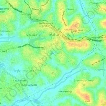
Name: Godigamuwa topographic map, elevation, terrain.
Location: Godigamuwa, Colombo District, Western Province, 10280, Sri Lanka (6.82030 79.90397 6.86030 79.94397)
Average elevation: 52 ft
Minimum elevation: 3 ft
Maximum elevation: 118 ft
Thank you for supporting this site ❤️
Make a donation
Make a donation
Gear up for your next adventure:
As an Amazon Associate, this site earns from qualifying purchases at no extra cost to you.