Geolocate

Eye topographic map

Click on the map to display elevation.

About this map

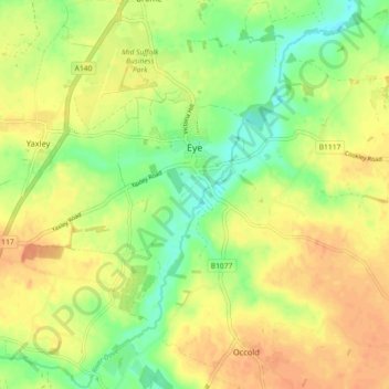
Name: Eye topographic map, elevation, terrain.

Location: Eye, Suffolk, England, United Kingdom (52.29320 1.10996 52.33857 1.20015)

Average elevation: 144 ft

Minimum elevation: 79 ft

Maximum elevation: 194 ft

Other topographic maps

Click on a map to view its topography, its elevation and its terrain.

Wenhaston

United Kingdom > England > Suffolk > East Suffolk

Average elevation: 52 ft

Felixstowe

United Kingdom > England > Suffolk

Average elevation: 20 ft

Minsmere

United Kingdom > England > Suffolk > East Suffolk

Average elevation: 20 ft

Exning

United Kingdom > England > Suffolk > West Suffolk

Average elevation: 75 ft

Gear up for your next adventure:

🚁Photography Drones - Capture stunning aerial views of landforms and topography
🧯Portable Fire Pit - Compact fire pit for camping spots
🔥Plasma Lighters - Windproof lighters that work in any weather condition
📚Navigation Handbooks - Master the art of reading topographic maps and using a compass
Solar GPS Watches - Advanced multisport watches with built-in topographic maps

As an Amazon Associate, this site earns from qualifying purchases at no extra cost to you.