Geolocate

Exning topographic map

Click on the map to display elevation.

About this map

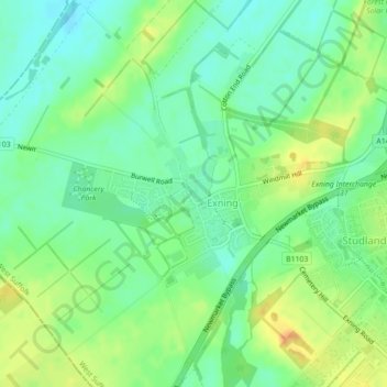
Name: Exning topographic map, elevation, terrain.

Location: Exning, West Suffolk, Suffolk, England, United Kingdom (52.26027 0.35796 52.27186 0.38706)

Average elevation: 75 ft

Minimum elevation: 30 ft

Maximum elevation: 141 ft

Other topographic maps

Click on a map to view its topography, its elevation and its terrain.

Red Lodge

United Kingdom > England > Suffolk > West Suffolk

Average elevation: 72 ft

Elveden

United Kingdom > England > Suffolk > West Suffolk

Average elevation: 141 ft

Ingham

United Kingdom > England > Suffolk > West Suffolk

Average elevation: 141 ft

Mildenhall

United Kingdom > England > Suffolk > West Suffolk

Average elevation: 46 ft

Clare

United Kingdom > England > Suffolk > West Suffolk > Clare

Average elevation: 226 ft

Exning

United Kingdom > England > Suffolk > West Suffolk > Exning

Average elevation: 66 ft

Gear up for your next adventure:

🧭Hiking Compass - Precision compass for reliable navigation in the wilderness
🧤Tactile Hiking Gloves - Keep hands warm while operating GPS and smartphone screens
📌Outdoor GPS Map App - Apps and devices for digital topographic navigation
📶Vehicle Signal Boosters - Improve reception in rural areas while driving to trailheads
🏕️Family Camping Gear - Essentials for group camping trips

As an Amazon Associate, this site earns from qualifying purchases at no extra cost to you.