Geolocate

Jejuri topographic map

Click on the map to display elevation.

Jejuri

Jejuri is located at 18°17′N 74°10′E / 18.28°N 74.17°E / 18.28; 74.17. It has an average elevation of 718 metres

Wikipedia (CC-BY-SA 3.0)

About this map

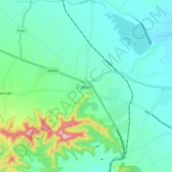
Name: Jejuri topographic map, elevation, terrain.

Location: Jejuri, Purandhar, Pune District, Maharashtra, 412303, India (18.23690 74.12023 18.31690 74.20023)

Average elevation: 2,388 ft

Minimum elevation: 2,162 ft

Maximum elevation: 3,261 ft

Other topographic maps

Click on a map to view its topography, its elevation and its terrain.

Purandar Fort

India > Maharashtra > Purandhar > Narayanpur

Average elevation: 3,369 ft

Purandar Fort

India > Maharashtra > Purandhar > Narayanpur

Average elevation: 3,369 ft

Gear up for your next adventure:

🚗GPS Dash Cams - Record your scenic drives through mountain passes and canyons
🌲Outdoor Survival Books - Best books on survival skills
🪶Multi‑Purpose Knife - Useful blade for camp and trail
🏕️Family Camping Gear - Essentials for group camping trips
Backpacking Tents - Weight-optimized shelters for multi-day topographic surveys

As an Amazon Associate, this site earns from qualifying purchases at no extra cost to you.